Soil, Subsoil and Bedrock Pathways
![]()
Dr. Per-Erik Mellander
Linking the nutrient source with catchment rivers via PATHWAYS in the soil, subsoil and bedrock
Background
Inefficient use of N and P can lead to the excess being mobilised and transported from agricultural land to surface waterways and groundwater via pathways such as surface runoff, erosion and deep drainage of water. Nitrogen is more mobile through soil than phosphorus so tends to get transported through subsoil and porous bedrock material. Phosphorus is well ‘fixed’ by all but the most sandy or peaty of soils and so tends to be transported mainly via overland pathways across soil surfaces and in near-surface drains. Both N and P can also be directly discharged to waterways when stock access streams and if waste from farm yards and milking parlours is not correctly stored and spread. In order to link land management activities (‘Source’ information) to nutrient delivery at the catchment outlet, an understanding of the pathways of nutrient movement is required. A conceptual model of the pathways of nutrient movement is being developed for each catchment. These models represent our current understanding of where water originates (eg springs), where it travels (eg the drain network), how it travels (eg over and/or through the soil or bedrock), when it travels (eg as year-round baseflow or mainly as winter event flow) and where it is delivered (eg to streams and/or groundwater). Information about the farming systems in each catchment is then used to develop a conceptual model of the most likely periods when, and from where, nutrients are mobile within the landscape.
Objectives
Measuring water and nutrient flux from the source and in the surface water is manageable with direct methods. Pathways in the subsoil and bedrock, on the other hand, are often seen as a part of a “black box” requiring large resources to monitor and especially in a catchment-scale when we often have to rely on indirect methods. This project will handle this by conducting demonstrative studies on how water finds its way to the stream via the soil, subsoil, subsoil/bedrock interface and bedrock.
The main contribution of this work is to (i) identify and quantify water and nutrient pathways from the nutrient source and into the surface waters of the catchments, (ii) to estimate spatial and temporal changes in these pathways and (iii) to quantify the catchments’ runoff sensitivity. The underlying hypotheses of the work are:
- There are both surface and subsurface water flow pathways that link farm nutrient sources with streams
- The streams in well-drained catchments are mostly groundwater driven
- Most of the stream discharge in well-drained catchments originates from shallow groundwater in the subsoil/bedrock interface, whereas most of the stream discharge in catchments with heavy soils is from overland flow.
- Water flow pathways differ between winter and summer
Methods
An overall understanding on how flow path processes and catchments’ runoff sensitivity relates to its “hydro-characteristics” will be built to add information to our conceptual model of the flow systems. Parameters such as the average ratio of rainfall to stream flow will be used to compare the catchments as this parameter typically varies with soil type, bedrock and land cover. The lag time between peak rainfall intensity and peak stream discharge during events will further be determined, and the recharge processes will be quantified by closing the water balance. An important part of these studies is to monitor the weather, where a weather station is placed in the central lowlands of each catchment and augmented by an additional rain gauge in the higher altitudes (Fig 1).
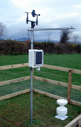
Figure 1. Weather station in the lowlands of Castledockrell catchment, Co. Wexford. Parameters such as air temperature, relative humidity, global radiation, precipitation, and wind speed and direction are measured in a 10-minute time step. The measurements are used to estimate potential evapotranspiration, which together with precipitation and stream discharge can be compared with national stations and be used to close the water balance and estimate the catchment recharge. |
Demonstration studies on how water finds its way to the stream via the soil, subsoil, subsoil/bedrock interface and bedrock will be conducted to further develop the conceptual model on flow systems that link nutrient source to surface waters. In catchments with dense soils, these will be surface and near surface pathways and sites that include overland flow dominance, or convergent flow in the near surface, will be monitored. In the catchments with well drained soils (e.g. Fig 2), on both productive and unproductive aquifers, studies will be carried out where a substantial subsoil/groundwater flow to the stream is assumed to occur. Water level, temperature and electric conductivity will be monitored in transects of piezometer nests. Ground and/or subsoil water flow patterns are then derived from gradients in water potential. Low-flow groundwater sampling will be carried out for water quality analysis. The piezometer transects are located on representative sites referring to land use and on zones of different depths to regolith. These sites are described geophysically with a survey based on electro magnetic and seismic refraction methods. The subsoil/groundwater flowpaths are likely to change between summer and winter conditions due to the influence of ephemeral streams in winter. The flow paths will therefore be identified and quantified for both conditions.
Mixing models will be used to quantify pathways from different chosen zones of contribution; such as deep groundwater, bedrock/subsoil interface, subsoil and surface during event flow. The chemical signal in terms of major chemical parameters (e.g., NO3-N, PO4-P, Si, Ca and EC) will be used to find chemical signatures for each of these potential water sources. The stream water quality will be analyzed during rain events to reveal how much each of the flow sources contributes to the stream discharge during that event. The flow sources will vary temporally, dependent on antecedent soil conditions. Studies of stable isotopes in rain, soil water and stream discharge will add more information on how much the groundwater contributes to the discharge.
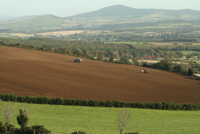
Figure 2. There are pathways from the uplands of the catchment and into the stream that link nutrient source with surface water via the subsoil environment. Tillage in Castledockrell catchment, Co. Wexford. |
Outcomes
This part of the programme will add conceptual understanding to the link between nutrient use, or source, at the farm and field scale to those patterns of nutrient delivery in catchment streams. Pathways are the connection and understanding these will add clarity to management options in potential hot-spots of nutrient loss and also conceptual understanding for catchment based models.
For further information, please contact Dr Per-Erik Mellander.