21 October 2024
How weather patterns are changing, what are we adapting to?
As part of the recent Teagasc Grassland Climate Adaption Conference, Met Éireann’s Pádraig Flattery outlined how Ireland’s climate has changed and how it is likely to continue changing in the future.
Introduction
Ireland’s climate is predominantly influenced by its geographical position in the northeast Atlantic Ocean, resulting in a temperate maritime climate. This produces mild winters and cool summers, with significant rainfall and frequent cloud cover.
The Atlantic Ocean, along with the North Atlantic Current, ensures that sea temperatures around Ireland remain relatively high for its latitude, buffering the island from extreme seasonal fluctuations.
Ireland’s prevailing weather patterns are also impacted by the clash of air masses, which can bring about unpredictable shifts in weather, including strong winds and storms, particularly in the winter months.
Ireland’s long-standing climate patterns are undergoing changes because of climate change. Rising global temperatures are increasing the likelihood and intensity of extreme weather events, such as heavier rainfall, which poses a challenge to Ireland’s infrastructure, agriculture, and natural ecosystems. In this context, Ireland will need to adapt to both the gradual shifts in temperature and the more immediate consequences of erratic weather patterns.
Climate change in Ireland
Climate averages are the mean values of a climate variable over a standard reference period. The World Meteorological Organization (WMO) established that the length of the reference period should be 30 years, with a recommendation to update the climate averages every 10 years to provide representative reference values for recent climatic conditions.
These averages include data such as temperature, rainfall, and wind patterns, which help provide a baseline for comparing current weather conditions to historical trends. Using climate averages allows scientists to identify deviations from expected patterns and track long-term changes in climate. Averages are essential for understanding shifts in regional weather patterns and for planning in sectors like agriculture, infrastructure, and disaster preparedness, where knowing average conditions is vital for effective decision-making.
In accordance with WMO guidelines, Met Éireann has compiled a set of climate averages for the period 1991-2020 for a range of parameters including air temperature, precipitation, sunshine and wind. Annual, seasonal, and monthly average values for the period 1991- 2020 were compiled using quality-controlled data obtained from Met Éireann’s observation network. Hundreds of weather stations across the country were used for analysis. Long-term averages for stations are then used to generate maps and gridded data at a 1 km resolution. Figure 1 shows how seasonal temperature has changed.
Figure 1. Seasonal temperature change (°C) for the period 1991-2020 compared to 1961-1990
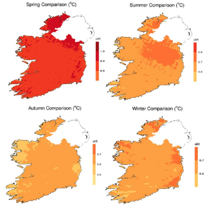
Key highlights from 1991-2020 include a rise in Ireland’s annual mean air temperature to 9.8°C, this ranges from approximately 8.5°C to 10.8°C. Due to the moderating influence of the sea, areas closest to the coast are generally warmest while areas at higher elevations are the coolest. The mean annual air temperature has increased by 0.7°C compared to 1961-1990. Spring temperatures increased by 0.8°C, summer and autumn temperatures increased by 0.7°C, and winter temperatures increased by 0.6°C.
Rainfall has also increased over the reference period; Ireland was 7% wetter in the 1991- 2020 period compared to 1961-1990. Average annual rainfall in Ireland is now 1,288 mm, with much more rainfall falling in the west and at upper elevations.
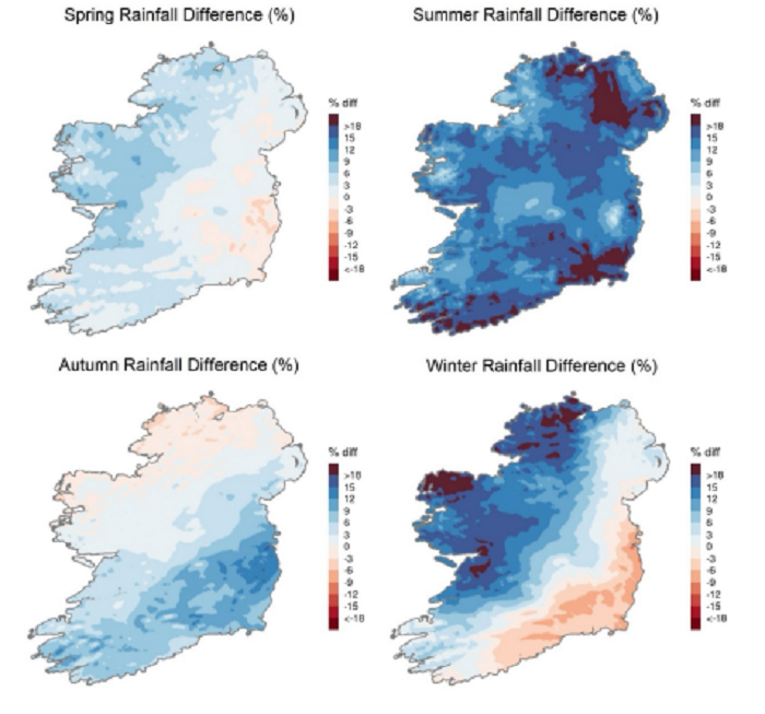
Figure 2 shows how rainfall has changed on a seasonal basis, with clear spatial differences in different seasons. Summer rainfall had the greatest relative change, increasing by 12%. Winter rainfall has increased by 7% on average, but notably increased strongly in the west and northwest of the country while declining in the east and southeast. Spring and autumn show increases of 3% and 4% on average, respectively.
Figure 2. Seasonal precipitation change (%) for the period 1991-2020 compared to 1961-1990
There has also been a change in sunshine hours, with an average of 1,387.5 hours annually, an increase of 4.9% compared to the previous period. Wind speeds remain highest in the northwest, with Malin Head recording the strongest winds.
Storms and rainfall from October 2023-March 2024
A rapid attribution study by the World Weather Attribution group that involved Met Éireann scientists examined the links between climate change, storminess and rainfall in 2023/2024. The study found that rainfall associated with storms during this period was about 20% more intense and ten times more likely to occur compared to a pre-industrial climate. If warming reaches 2°C, as it is expected to in the 2040s or 2050s, unless emissions are rapidly halted, storm rainfall like we saw recently will become about 4% more intense again, and will be expected to occur about once every three years.
The study also examined the consistent wet weather over this period. In the cooler, preindustrial climate, wet periods such as the 2023-24 October-March season occurred at most once every 80 years. However, in today’s climate, they have become at least four times more likely, and are expected to occur about once every 20 years. The scientists estimate that climate change contributed to increasing the amount of total rainfall over the period by about 15%.
Future climate change
The TRANSLATE project, led by Met Éireann, is a collaborative initiative aimed at providing Ireland’s first-ever standardised and bias-corrected national climate projections. These projections show how Ireland’s climate will change under various global warming scenarios (1.5°C to 4°C), supporting informed adaptation strategies across key sectors.
TRANSLATE projections are utilised in sectoral adaptation plans and provide data that can be used to produce climate services for a range of sectors including agriculture. Projections indicate future increases in temperatures annually, with drier summers and increased rainfall in winter projected as the climate continues to change.
As the world warms, Ireland’s temperature and rainfall will undergo more and more significant changes, for example in the worst-case scenario, average summer temperature could increase by more than 2°C, summer rainfall could decrease by 9% while winter rainfall could increase by 24%. The growing season is projected to start earlier and to last for longer.
Conclusions
Ireland’s climate is changing, we have warmed by 0.7°C and become 7% wetter over the period 1961-1990 to 1991-2020. This change has led to increased likelihood and intensity of rainfall associated with storms, and of prolonged wet periods in general. A warmer atmosphere carries more moisture (about 7% for each degree of warming) so this rainfall increase is consistent with what we could expect as the climate warms. The severity of future climate change depends on global greenhouse gas emissions reductions, the more warming we experience, the more severe the impacts will be.
Acknowledgements
Information in the above comes from Met Éireann’s research into climate averages , the World Weather Attribution study into the extreme rainfall of 2023/2024, and the TRANSLATE climate change projections.
The above by Pádraig Flattery, Met Éireann, first appeared in the Climate Adaptation Conference proceedings. For more insights, access the full publication here.
Also read: Coping with climate change – conference hears of necessary grassland adaptions