Caution: windthrowing!
If a tree falls in the forest and no one is around to hear it, the effects certainly make themselves heard across the forestry supply chain. A new framework developed at Teagasc Johnstown Castle aims to protect forestry managers from the worst effects of windthrow.
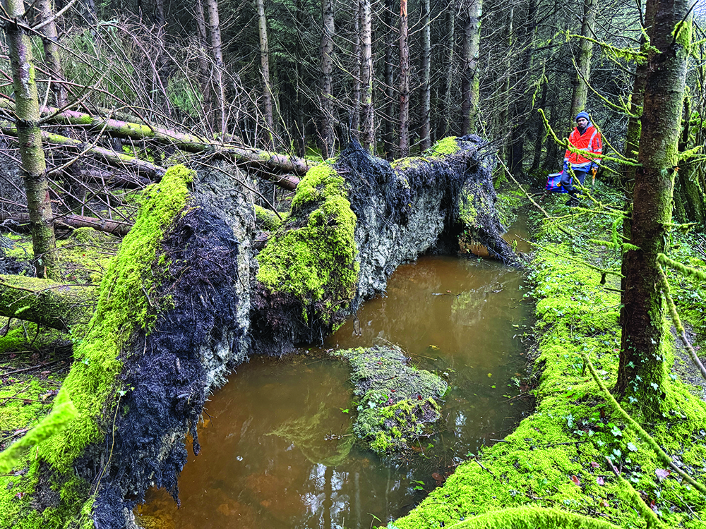
Walsh Scholar Emmanuel Ekeoma investigates a site affected by windthrow near Johnstown Castle. Photo credit: Teagasc.
Windthrow, the uprooting of trees by wind, represents the single most significant natural threat to the stability and economic viability of the Irish forestry sector. While the industry has long managed the risks of extreme weather, the escalating scale of storm damage suggests that a business-as-usual approach is no longer tenable.
Compare the impact of Storm Darwin (2014) with Storm Éowyn (January 2025); the former destroyed approximately 8,000 hectares, whilst the latter devastated 23,652 hectares, representing 227% of the typical annual harvest volume.
To help forest managers better understand and mitigate potential risks, a research project at Teagasc Johnstown Castle is developing a framework to create site-specific forestry ‘vulnerability maps’.
Ripple effects
Teagasc Walsh Scholar Emmanuel Ekeoma is one of the researchers behind the framework. He explains that the impact of windthrow events ripples through the entire supply chain.
“These events increase harvesting risks and make strategic planning challenging. Salvage volumes can dwarf standard capacity, causing economic devaluation and disruption of timber supply; the premature harvesting of crops floods the market and reduces prices.”
Add to these the difficult, sometimes dangerous working conditions after storms – unstable trees, restricted access and time pressure – and it becomes clear why windthrow disrupts both short-term operations and long-term planning.
“There is also a climate dimension that is easy to miss when we focus only on clearing up the mess,” Emmanuel continues.
“Forests deliver climate value by storing carbon in wood and soils. When trees fall before the planned harvest age, that ‘future carbon capture’ is cut short. Where tree overturning disturbs the soil – especially in wetter or more organic soils – carbon that has been locked in the soil for decades can be released.”
In other words, windthrow can reduce the climate benefit of forests in two ways: removing trees that would have kept growing, and by disturbing the carbon-rich soils beneath them.
A new approach
Whilst risk is inherently site-dependent, the sector’s historic ability to mitigate these impacts has been limited – largely due to the interdisciplinary nature of the challenge. Storms are meteorology, wind flow through forests is fluid dynamics, tree stability is biomechanics, and root anchorage is geotechnical engineering, depending on soil strength and water conditions. The pattern of damage is also spatial and often ‘contagious’, with one failure increasing the risk of the next.
“These elements are usually studied separately, which makes it hard to see the full risk picture for a forest,” Emmanuel notes. “We have undertaken the first step to addressing this by developing a new, dynamic, overarching framework. It shifts the focus from an empirical approach to considering failure due to mechanical impacts.
“At its heart, the framework aims to provide what forest managers repeatedly ask for: decision-ready outputs that show where risk is high, why it is high, and how confident we are in that assessment.”
Using the framework’s inputs, researchers then model the dynamic behaviour of a tree and ascertain its likelihood to fall.
“When a tree falls, it exposes the trees next to it to more wind loading, transforming a single point of failure into a potential wider failure chain reaction,” explains Emmanuel. “This framework allows us to visualise not just if a tree will fall, but how an entire stand might succumb.”
The framework’s accuracy was confirmed by contrasting drone imagery of actual damage against the model’s predicted spatial distribution. Crucially, the model captured the spatial distribution of failures coloured by failure wind speed, matching the physical reality on the ground and proving its ability to predict at what specific intensity different clusters would fail.
Scalable framework
Ultimately, this framework is designed to serve as a digital twin allowing managers to simulate interventions before deployment. It can support decisions about thinning, harvesting, replanting layouts and risks prioritisation – not by replacing professional judgement, but strengthening it with site-specific evidence.
“Our approach is intended as a solution, not just a model. In practice, the model would sit behind a simple mapping tool that forest managers can access via a web portal,” Emmanuel concludes.
“Stands will be coloured by windthrow risk and confidence with options to overlay soil and harvest plans. This means vulnerable areas can be identified in advance and prioritised for earlier harvesting, alternative species, or extra protection along exposed edges.”
As additional field and post-storm data are integrated, the framework can be scaled to support climate-smart forestry – strengthening adaptation and protecting long-term carbon capture by reducing avoidable storm losses.
A dynamic model to assess fall risk
The framework integrates three distinct data layers to create site-specific vulnerability maps:
Remote sensing: Used to identify individual trees within a stand and extract key structural attributes, including tree height and crown dimensions.
Geotechnical: It uses soil maps to characterise spatial variation in soil strength across the forest and integrate these data with tree root models to estimate the anchorage of individual trees.
Meteorological: The framework uses wind speed data to quantify the forces acting on trees, and precipitation data to assess how soil conditions — and therefore anchorage — may vary over time. This is important because the same wind speed can have very different consequences depending on whether soils are relatively firm or waterlogged.
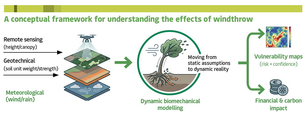
A conceptual framework for understanding the effects of windthrow. Graphic credit: Teagasc.
Funding
Funded by the Teagasc Walsh Scholars programme.
Acknowledgements
The authors wish to thank the Walsh Scholars programme for funding the four-year study and to all laboratory staff who have helped with collection and analysis of data. We also thank the other two Teagasc supervisors on the project: John Spink and Niall Farrelly.
Contributors
Emmanuel Ekeoma, Walsh Scholar, Teagasc Johnstown Castle/University of Birmingham.
Nicole Metje, Director, National Buried Infrastructure Facility University of Birmingham.
Mark Sterling, Pro-Vice-Chancellor, Faculty of Science and Engineering Manchester Metropolitan University.
Owen Fenton, Principal Research Officer, Teagasc Johnstown Castle. Contact: owen.fenton [at] teagsasc.ie