
Road-Ready
 Design and Implementation of Mitigation Measure Toolbox to Disconnect Farm Roadway Runoff Nutrient Losses from Waters
Relatively small but critical source areas within agricultural catchments tend to contribute disproportionally to nutrient concentrations in receiving waters, and require identification followed by targeted remediation strategies. Farm roadways typically retain excessive nutrient concentrations, particularly phosphorus (P), and have been little investigated with respect to their role in nutrient transport to receiving waters. Critical farm roadway sections are those that have all components of the nutrient transfer continuum, including source, mobilisation, transport, hydrological connectivity, delivery, and impact. Achieving water quality goals outlined by the EU Water Framework Directive requires reductions in nutrient point and diffuse sources, and mitigation of pathways delivering those nutrients to surface water receptors. There is therefore an urgent need to establish the effectiveness of roadway runoff mitigation measures and to develop a strategy of ‘right place, right management option’, particularly for existing critical roadway sections. The primary objective of the ROAD-READY project is to evaluate the extent and connectivity risk of farm roadway runoff to waters and assess effectiveness of a variety of mitigation and management options to break the pathway. The ROAD-READY project collaborates with farm and landowners within the Teagasc Heavy Soils Programme and Agricultural Catchment Programme (ACP).
Objectives
- To measure and compare spatial and temporal available P concentrations within roadway substrate in different farm enterprises such as dairy and beef farms
- To develop an automated/semi-automated connectivity risk assessment tool for farm roadway runoff to waters using a combination of novel techniques such as GIS and aerial imagery
- To design and assess efficacy of on- and off-roadway mitigation and management options to reduce the negative impact of farm roadway runoff to waters.
Work to date
The first objective, which is to measure spatial and temporal P concentrations within farm roadway substrates on pastoral farms, has been completed. The spatial and temporal variability of the P concentrations was assessed and compared for dairy and beef farms for 8 months, covering the closed and open periods. Results indicated that P concentrations on the roadway substrates in both dairy and beef farms were elevated (greater than the P concentrations on soil from adjacent fields), especially on bends, underpasses and junctions, and forms a subcomponent of the nutrient transfer continuum. On the dairy farm, the P concentrations were up to 4 times greater than on the beef farms. The spatial and temporal signal of beef farms although lower than that of the dairy system was significant and therefore needs to be managed within critical source areas. Temporal data suggests that P is available all year round to be lost in roadway runoff. Highest concentrations are found during the open period but are sustained and start to decline over the closed period (due to lack of fresh deposits as cows are housed and frequent rainfall during that period) only to rise again once cows are given access to paddocks for grazing. Spatial distribution of P concentrations on roadway and trackway material was also assessed on a sheep farm for one-month data. Surprisingly, the P concentrations were high just like in the dairy farm – considerably higher compared to P in roadway substrates from the beef farms even though roadways are not extensively used in sheep farming. However, P source factors and the volume of excreta deposited on the roadway are determined by the stocking rate (about 4.5LU/ha for beef farms and 12LU/ha in the sheep farm in this case studies) and roadway density. Therefore, fresh excreta and nutrient enriched roadway materials are a labile P source and should be considered when implementing mitigation measures to break the pathway of roadway runoff to waters.
Publications
- Phosphorus in farm roadway substrates: contrasting spatial and temporal patterns in dairy and beef farms
- Spatial distribution of available phosphorus in surface road and trackway surface materials on a sheep farm in Ireland
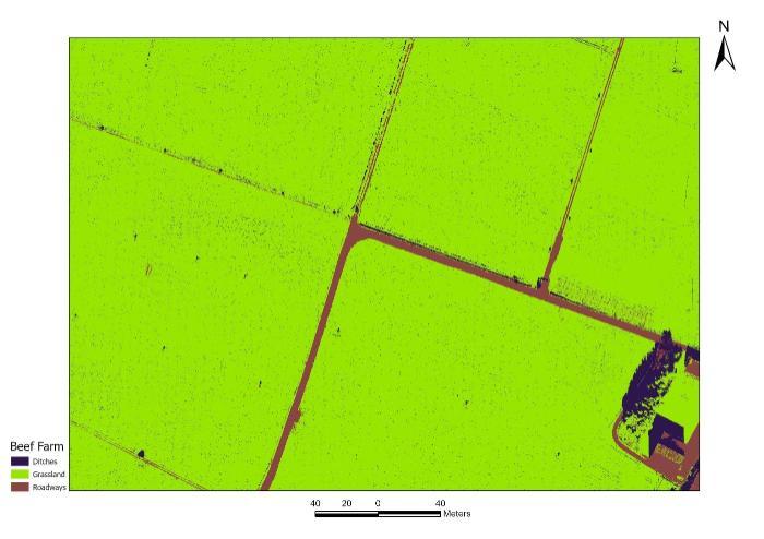
A model is currently being developed to automatically detect farm roadways in a given farm, and thus, (together with other modelled factors) we would be able to map critical roadway sections that require mitigation. Below is preliminary results of a machine learning to detect farm roadways and trackways which was implemented in one of the beef farms in Johnstown Castle, Wexford.
Project Partners
Lungile Senteni Sifundza, Teagasc PhD Student
Dr John Murnane, University of Limerick
Project Contacts

Pat Tuohy
Senior Research Officer

Luis Lopez-Sangil
Soil Quality Technologist & Lab Safety Coordinator

Owen Fenton
Principal Research Officer

Karen Daly
Head of Environment, Soils and Land Use Department

Gabriela Cárdenas-Álvarez
Environmental Research Technician

Russell Adams
Research Officer – Catchment Water Quality Modeller